| Restocking Fee | No |
|---|---|
| Return shipping will be paid by | Buyer |
| All returns accepted | Returns Accepted |
| Item must be returned within | 30 Days |
| Refund will be given as | Money back or replacement (buyer's choice) |
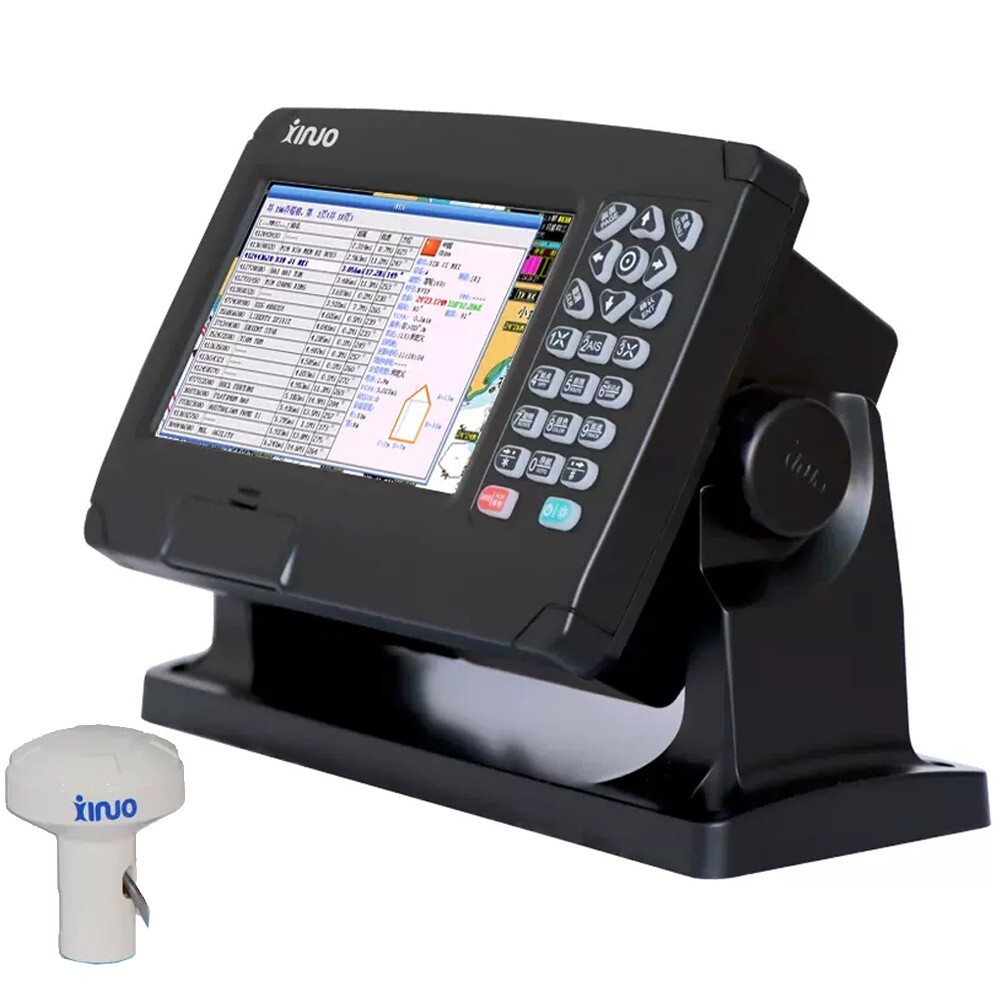
| Brand | Xinuo |
| Type | Marine Class B Automatic Identification System |
| Model | HM-5907 |
| MPN | Does not apply |
| Country/Region of Manufacture | China |
Check the listing for details. 7'' Marine AIS Class B Automatic Identification System BDS/GPS GNSS Chartplotter. Condition: New. Listed at 631.47 USD. 新建网页 1 template HM-5907 Marine AIS Class B Automatic Identification System BDS/GPS GNSS Chartplotter Description:Class B automatic identification system supports BDS, GPS dual-mode high-precision positioning. It is built-in Class B AIS module and installed with perfect AIS function. The AIS list supports 2000 ships’ information display. The AIS radar page intuitively shows the distribution of ships, and provides many types statistical data to meet the needs of different usage scenarios. It also has a variety of extension functions, such as fleet management, CPA alarm, which can meet the requirements of different users. Features:- 7 inch color LCD with 800 x 480 resolution, high brightness, wide angle of view.- Classic& Utility dual operating system, you can switch freely.- Built-in Class B AIS module, with perfect AIS function. It can timely respond to regulatory instructions.- Intelligent CPA alarm calculation mechanism can avoid outdated and ineffective alarms.- Install in intelligent voice to broadcast operation content, alarm content, etc- Connect to mobile network to upgrade software online.- Support to making ships being in a group to manage, and can set multiple alarm, such as anchor alarm, leave out alarm, etc.- Designed for counter mounting, flush mounting and other installation methods. Specification:ModelHM-5907Display TypeColor TFT LCDSize7 inchResolution 800*480Brightness500cd/㎡Language English, Simplified Chinese, Traditional Chinese, Vietnamese, Bahasa Malaysia, Turkish, Thai, Greek, Indonesian, Japanese, Korean, Spanish, Burmese, Persian Display Modes Standard Chart View, Pure Chart View, Simple Chart View, AIS Data, Sailing Data, GNSS, 3D Navigation, CompassMemory Capacity50,000 waypoints, 50,000 markers, 500 routes, one route can indicate 200 waypoints , 1000 tracks, 1600000 track pointsInterface1 Port AIS Output , 1 Port NMEA 0183 Output , 2 Ports NMEA 0183 Input (Baud rate can be set indenpently)WIFI802.11 b/g/nPower SupplyDC10V~36VPower Consumption10W or less (24V DC)AIS Class B Transceiver Frequency156.025MHz ~ 162.025MHzBandwidth 25kHzModulationGMSK / FMData Rate 9,600 bpsNumber of AIS Transmitter1Number of AIS Receiver2(Contains A and B channels)AIS Channel A (default) CH87B(161.975MHz)AIS Channel B (default) CH88B(162.025MHz)Output Power 2 WRx Sensivity< -107 dBm @ 20% PEREnviromentalStorage Temperature-20℃~+60℃Working Temperature-15℃~+55℃WaterproofIP65GNSSGNSS Receiver72 channels Receive FrequencyGPS L1: 1575.42MHz;BDS B1: 1561.098MHzAccuracyGPS&BDS2.5m(CEP50% open sky)GPS5m(CEP50% open sky)BDS5m(CEP50% open sky)Speed Accuracy0.1m/s(50%@10m/s)Time to First Fix Cold Start
You may also like


